An interactive map and table explorer for geographic coordinates in a spreadsheet, CSV file, or database

Project description
mapdata.py is a data explorer for data sets containing geographic coordinates. Data can be read from a CSV file, spreadsheet, or database. Both a map and a data table are displayed. When a location is selected on the map, the same location is highlighted in the table, and vice-versa. Single or multiple selections may be enabled. Locations may also be selected and highlighted by writing a query expression to select rows of the data table.
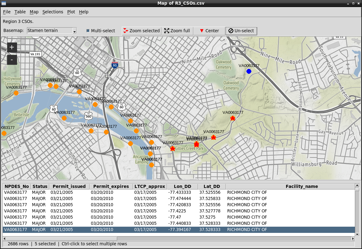
In addition to visually browsing the map and table, the user can produce a number of different tabular, graphical, and statistical summaries of the data. Most of these summaries can be applied either to the entire data set or to a selected subset of the data.
Map coordinates should be in decimal degrees, in WGS84 (coordinate reference system [CRS] 4326), however, coordinates in other CRSs can be converted to 4326.
The map display can be customized in several ways:
-
Different raster tile servers may be used for the basemap. The default is OpenStreetMap. Several alternatives are provided, and other tile servers can be specified in a configuration file.
-
Locations identified by coordinates in the data file may be designated by different types of markers and by different colors. The default marker for locations, and the default marker used to flag selected locations can both be customized. Symbols and colors to use for location markers can be specified in a configuration file and in the data file. Different symbols and markers can be used for different selected locations.
-
Locations may be unlabeled or labeled with data values from the data file The label font, size, color, and location can all be customized.
-
When there is more than one data value (table row) at a location, the number of rows can be annotated on the map adjacent to each location. In addition, data can be selected based on the number of data rows with the same geographic coordinates.
The map can be exported to a Postscript, PNG, or JPEG file. Using command-line options, mapdata can be directed to load a data file and display location markers and then to export the map to an image file, and quit.
Selected rows in the data table can be exported to a CSV or spreadsheet file.
Mapdata provides five different ways to show information about multiple data rows that all have the same geographic coordinates, and thus plot at the same location on the map.
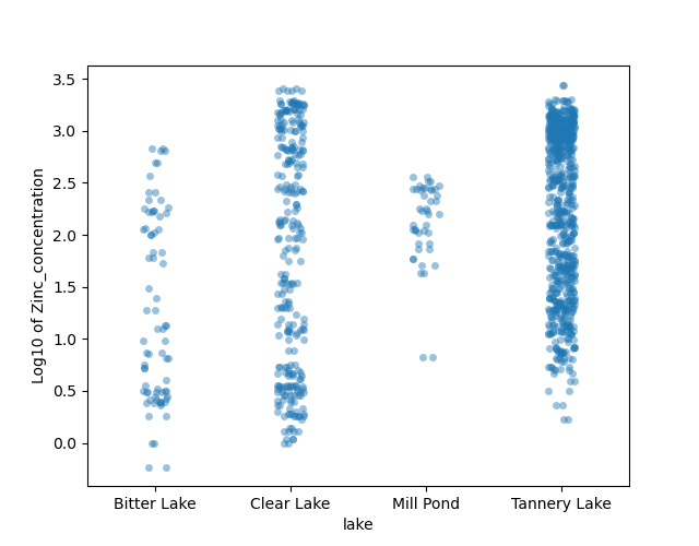
Data can also be displayed in several different types of plots: box plots, scatter plots, line charts, ECDF plots, Q-Q plots, Fisher-Jenks group plots, strip charts, and counts of categorical and quantitative variables. Plots can use either all data or only data values that are selected in the map and table. Plots have a live connection to the data table and map, so when data selections are changed the plots are automatically updated.
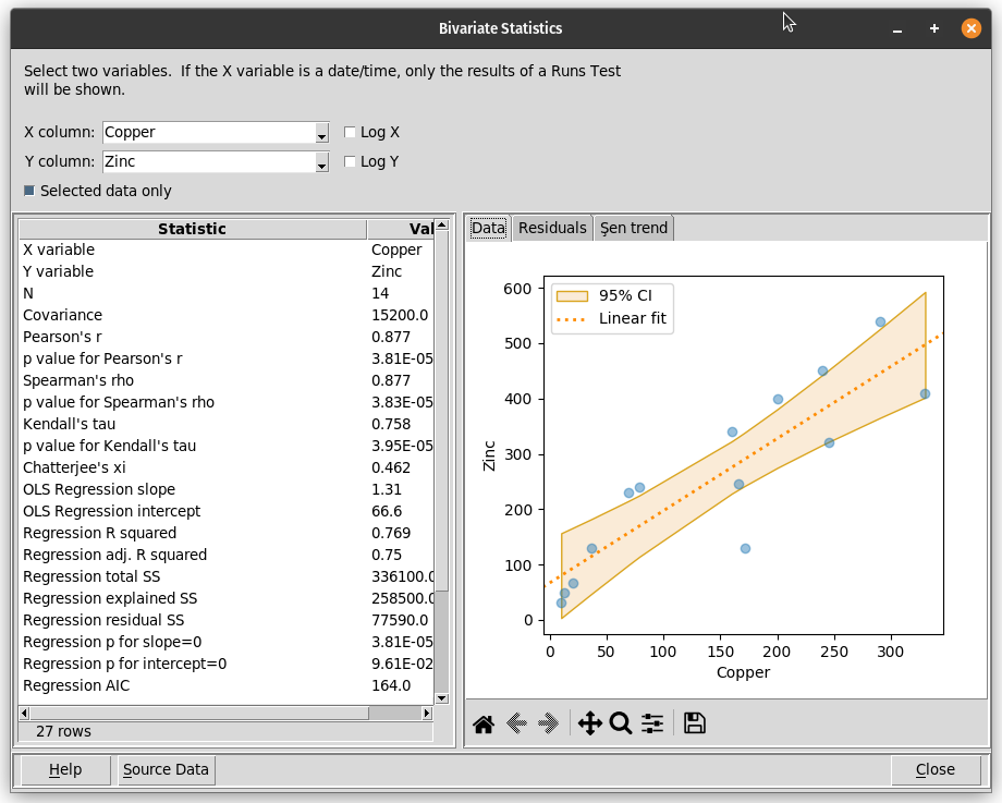
Mapdata can also display summaries of univariate and bivariate statistics for selected variables. These summaries can use either all data in the data table or only the data that are highlighted on the map. These summaries are updated immediately if different data are selected.
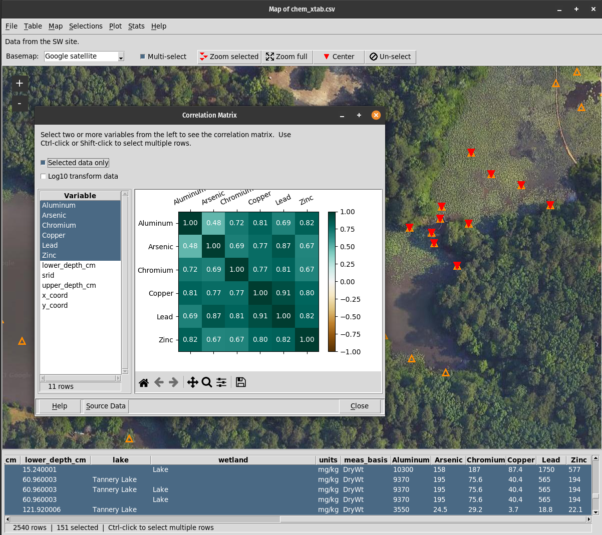
In addition to univariate and bivariate statistics, and plots, mapdata can display the relationships between variables in the form of:
-
A correlation matrix.
-
A contingency table, using either categorical or numeric variables, with flexible specification of groups. Tests of independence, risk ratio, odds ratio and related statistics, and conditional probabilities are all shown.
-
A Receiver Operating Characteristics (ROC) curve and measures such as sensitivity and specificity for a selected value of the predictor variable.
-
A scatter plot of the results of a t-Distributed Stochastic Neighbor Embedding (t-SNE) analysis of multiple variables.
-
A scatter plot of the results of a Uniform Manifold Approximation and Projection (UMAP) analysis of multiple variables.
SQL commands can be used when importing data from a database. The SQL commands can be augmented with execsql metacommands and substitution variables.
Complete documentation is at https://mapdata.readthedocs.io/en/latest.
A configuration file template and additional bitmap symbols are included with the distribution of mapdata.py.
Dependencies
Mapdata.py uses the following third-party Python libraries:
If mapdata.py is used to query a database to obtain a data set to view and explore, then one or more of the following Python libraries will have to be installed manually, depending on the type of DBMS used:
-
PostgreSQL: psycopg2
-
MariaDB and MySQL: pymysql
-
DuckDB: duckdb
-
SQL Server: pydobc
-
Oracle: cx-Oracle
-
Firebird: fdb

Release history Release notifications | RSS feed


Download files
Download the file for your platform. If you're not sure which to choose, learn more about installing packages.


